Historical context
The house was built in 1720. The kitchen garden is 135 metres to the east of the house, with an enclosed orchard to its west, shown on the 1st edn OS (1877) map.
Walled Kitchen Garden
The irregular shaped walled kitchen garden, which lacks walls on the south side, occupies 0.27 ha (measured between the southern ends of the east and west walls). The boundaries of the orchard to the west are no longer visible. The 1st edn map also shows peripheral paths around the main kitchen garden and through the orchard but these are no longer visible.
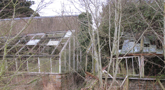
At the narrow north end of the garden there are three glasshouses in an east-west row, all of which are shown on the 1st edn OS map and are now derelict. Each has a lean-to shed or bothy attached to north side. The glasshouse to the west has an additional small building attached, perhaps a privy while the one at the centre is a larger building with windows, a loft, and the remains of a boiler and chimney. The third glasshouse has a taller lean-to structure, now inaccessible, which is not shown on the 1st edn OS map but is visible on 2nd edn (1899) and later OS maps. The centre and east glasshouses both have a cold frame attached to their south sides, although these might be later additions. A fourth glasshouse, shown on the 1st edn OS map just to the north of the row of three does not survive. This area may have been a frameyard.
The walls run south-east on the east side of the kitchen garden, and south on the west side. The walls are tall (2.4 – 2.9 metres), brick built in English Garden Wall bond and Irregular bond, and supported by numerous brick buttresses. The west wall is part restored due to storm damage. Copings are half-round brick, where original.


Current use
Derelict since mid-20th century. Southern half is now used as a paddock.
Special features
None
Designation status
None
Degree of completeness
Poor
Ownership and access
Privately owned. Limited public access: Ardington House
Sources of information
Unpublished site survey undertaken by volunteers with Oxfordshire Gardens Trust, January 2013
Name of district
Vale of White Horse
Grid reference
SU 43456 88244