Statement of significance
The ‘Paddock’ is a small roughly square recreation ground/park in the centre of Watlington, surrounded by houses dating from late medieval to the late 20th century.
Artistic Interest
Integral to the development of the park has been the provision of events, as requested by members of the public, of theatre, cinema, fairs and music.
Historic Interest
When the primary school vacated the old school building at the south side of the park and the site was converted into housing, as a gesture of goodwill the South Oxfordshire District Council (SODC) gave Watlington Parish Council an office and the ‘Paddock’ as a public park.
Historic Context and development
The historic heart of the village was west of the land that became the park, based around the Saxon church but the town spread when King Offa arrived in the late 13th century. The High Street came into existence between 1150 and 1480, with further expansion in the 12th – 14th centuries. At some point in the town’s history there were 27 inns. This may have been to accommodate large numbers of itinerant men and animals. In an informal conversation with Tim Horton, counsellor and local historian, Tim expressed his belief that Watlington was an important drovers’ town. He also states that Cromwell started his spring campaign against Charles I from Watlington, as it was the only place that could feed and water the large number of horses required. Later, Royalist forces were quartered in the town before the King decided to move his garrison to Oxford.
Re-drawn detail 1815 Enclosure Map
On the enclosure map of 1815 the area is shown as having three distinct strip fields which may have been attached to Windmill Farm at the north of the plot. (It is believed that at sometime there was a windmill on the land). By the Ist edn Ordnance Survey (OS) map (1876) the school has been built (1874) and there are two fields only. By 1973 the OS shows the west field has been built on and the east field is described as the ‘Playing Field’ but it is unclear whether this is associated with the school or a recreation area for the town. A photograph in 1905 shows sheep grazing in the field, outside the children’s playgrounds at the north side of the school building and a picture in 1911 shows rough grass (Picture Oxon).
The ‘Paddock’ occupies part of a much larger square of land (approx. 4 hectares) circled by roads and houses. The Bryant map of 1823 indicates the same shape and size but with multiple strips fields filling the square and additional housing around the perimeter. Among the present houses 12 are listed (Grade II) with three dating back to the late 16th century.
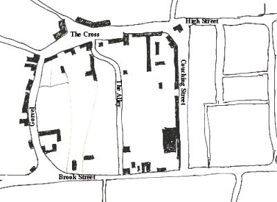
The roads bounding the square in which the park sits are High Street (named as The Cross leading into Hill Way on the Inclosure map 1815), Couching Street, Brook Street and Gorwell (Gorvel on the Inclosure map). A foot path historically known as ‘The Alley’ but now Davenport Place, runs north/south and divides the plot approximately in half. The Paddock lies to the west of Davenport Place. After a lengthy argument between counsellors as to the siting of a school to comply with the regulations of the Forster Act (1870), finally land was purchased adjacent to Brook Street and a school was completed by 1874. Originally designed with boys and girls in different halves of the building, as education changed and the population grew it eventually became a mixed primary school. By 2000 it was deemed no longer ‘fit for purpose’ and the school was moved alongside the local secondary school, Icknield Community College, on the northern outskirts of the town. The old school building is now accommodation for the elderly of Watlington, with the local council offices adjacent.
Application for a change of use from playing field to public park/recreational area was made to the SODC Planning Office by the parish council in November 2001. Included in the approval was a stipulation that the plan should be started within five years and also that a landscape design be implemented, including live trees and shrubs, path ways and fencing. It also stated there should be no artificial lighting used between 11pm and 6.00am and an amplification system should be limited to no more than 14 days per annum. By 2002 a detailed landscaping design and maintenance plan had been put in place.
Location, Area, Boundaries and landform setting
Site description
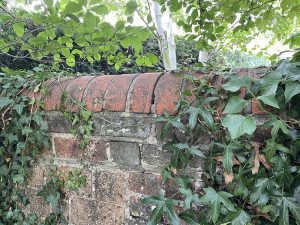
Detail of capping on wall bounding the park at the end of Gorwell gardens
The park is a small square of 0.375 hectare, 343 metres above sea level and sitting on clay, silt and gravel. The boundary to the north of the park comprises part hedging and part metal fencing. The west side boundary is the end of the gardens of the houses on Gorwell. The edge of the old school accommodation is a combination of wall and fencing and the west boundary running down Davenport Place has metal railings.
Entrances and approaches
There are four entrances to The Paddock, three of which are pedestrian only gateways and the fourth has a pedestrian opening attached to a larger vehicle access gate which can be unlocked when necessary. From High Street there is a road called Old School Place between the Library (Grade II listed) and an antiques shop leading to the library car park which then brings you to a farm style gate and entrance to the park from the north. Also from High Street is the entrance to Davenport Place, a tarmac path which twists between a selection of houses and then offers an entrance to the northern part of the park by the children’s play area and also an entrance at the south end of the park. The fourth entrance is at the south west corner of the park and winds round the end of the old school building.
Buildings, features, facilities
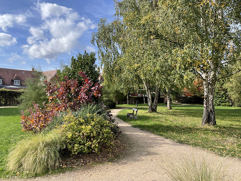
The park offers a small fenced off children’s play area with modern play equipment including a small slide and climbing net. There are several benches around the park and a picnic table with attached seating.


Horticulture
The park was designed by garden designer Sue Goss. The planting is both simple and varied with great attention paid to an interesting selection of trees. Part of the visual success of the park is created by the eight multi-stemmed Betula utilis jacquemontii planted in a wide circle that follows a curving north south path and continues into the grass on the west side of the park. At the north entrance there are 12 trees, some that were extant and some additional specimens purchased through donation by the Charlotte Cox Trust who own and manage the Library. The trees include a horse chestnut, a beech, a plane, a Swedish whitebeam, a lime, a walnut, a hornbeam and a callery pear. To mark the boundary at the north is a hedge of mixed hawthorn and field maple. To create the west hedge of the park,17 Crataegus persimilua prunifolia were planted making a strong backdrop for a selection of shrubs including viburnum, berberis, buddleia, ilex and climbing roses – Rosa glauca, Rosa odoratum, Rosa eglantis. Included in the border is a ‘butterfly bed’ planted with Ceonothus thyrsiflorus repens, Caryopteris Heavenly blue, Phlomis fruticosa and Ceratostigma willmottianum.
The border on the east following Davenport Place and the border running down the centre of the park contain lower growing shrubs with all year round colours, bee friendly flowers and added structure from grasses. Emphasis on bee friendly plants is apparent from the inclusion of hebes, sedums, lavender, rosemary and salvias.
The park was planted throughout with a wide selection of bulbs that would naturalise to ensure continuing interest. Under the trees at the north are camassia, narcissus poeticus, anemone blanda, snowdrops and bluebells. In the west border are tulips, colchicums, and alliums. The planting in the east includes gladious byzantinus, scillas, tulips, alliums, crocus and eremurus. Underplanting of the silver birches includes camassia and daffodils.
The degree of preparation and continuing care contributes to the success of the cultivation in the park. The land was initially cleared of meadow turf and perennial weeds to a depth of 30cm. Planting holes were backfilled with pelleted chicken manure and most areas covered with a 50mm layer of mulch. A three-year maintenance schedule was put in place.
Current use
The park is in constant use as a pleasant thoroughfare. It is very important as a community space for entertainment. It has a film club for outdoor films, hosts jazz bands, puts on plays and has musical evenings with tribute bands. The Watlington Phoenix Players play a part in the organisation of the entertainment.
Ownership and access
Watlington Parish Council
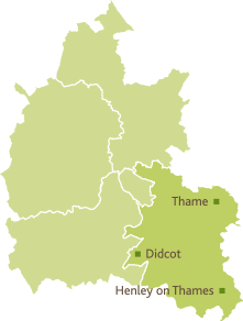
Name of district
South Oxfordshire
Grid reference
SU 68808 94479
Sources of information
Oxford History Centre: Watlington Board School 1873-1980, S279/1
Maps
Bryants Map of Oxfordshire 1823, Picture Oxon, POX0250972
https://heritagesearch.oxfordshire.gov.uk/images/POX0250972, accessed October 2023
Oxford History Centre: Enclosure Award 1815 QS/D/A/volF, Acc 4436
OS Oxfordshire Sheet XLVII SW, revised 1897, published 1900 (NLS, CC)
https://maps.nls.uk/view/101458110
Historic England
https://historicengland.org.uk/listing/the-list/results/?search=Watlington&searchType=NHLE+Simple
Picture Oxon: https://heritagesearch.oxfordshire.gov.uk/image
Image: No:1996/42/242 Oxon: Watlington: Council School, Exterior Jan 1905,
Image: No:1996/42/204 Oxon: Watlington Council School. Exterior 7.6.1911
Acknowledgements
Tim Horton, Researcher and retired counsellor, with thanks for time and engagement
Kristina Tynan, The Clerk Watlington Parish Council, for grateful help and generous sharing of materials relating to the construction of the park, including Sue Goss’s designs